Is your team still mapping sales territories in Google Maps?
Three in ten businesses are still assigning sales territories geographically because it’s “the way things are done.” But using Google Maps to plot and plan sales territories is an old school approach. The territories have to be created manually, and it leaves a lot of room for error.
What does that mean for your business? Well, it can lead to missed prospecting opportunities, and more importantly, lost revenue.
To optimize your sales mapping process, you need to include details like prospect demographics, existing customer data and have clear boundaries. Otherwise, your sales reps will be door-knocking the same houses, crossing into each other’s territories, and ultimately—wasting their time.
Let’s dive into why using a free tool like Google Maps to do your sales territory mapping could actually be costing you money, and why you should start mapping territories in a smarter way.
4 Costly Limitations of Assigning Sales Territories with Google Maps
Sometimes, the best things in life aren’t free. And when it comes to sales territory mapping, using a free tool like Google Maps to plan your sales prospecting can cost you money in the long run.
It’s not that Google Maps is totally useless. In fact, our territory mapping software relies on it for geographical data. But if you’re using Google Maps as a standalone mapping solution, you’ll run into several costly limitations.
Problem #1 – No idea how many homes are assigned to reps
It’s a typical Tuesday morning, and your sales reps are out canvassing neighborhoods you’ve assigned them on Google Maps.
But, how many homes are they supposed to hit in that area?
If you’re using Google Maps, you’ll have no idea. The fact is, you could assign two reps to the exact same geographically sized area in Google Maps, but there is no way to know the actual number of homes you’ve assigned to each rep.
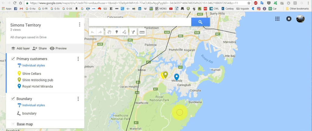
Unless you manually input every home in each sales territory, it’s impossible to know how many homes are in each one. [Image source]
One area might have 50 houses, and the other might have 500.
This is a recipe for disaster when it comes to making sure territories are fairly balanced. If a rep is constantly given areas with fewer homes than other reps, not only will they be closing fewer sales, but they might not be too happy about their commissions at the end of the month, either.
Problem #2 – No idea how many existing customers you have in each territory
Talk about flying blind.
Google Maps gives you the tools to assign territories. But it doesn’t give you any information about existing customers inside the area.
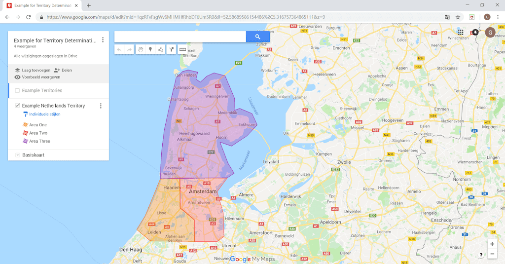
This is a problem for two reasons.
Firstly, your sales reps could be door-knocking current customers and trying to sell to them. This is a bad look and makes the rep (and your company) look unprofessional.
Secondly, it rules out any chances of reps using existing customers for referrals when they’re targeting a territory—because they’ve got no idea where the existing customers are located, and as a result, cannot customize their script.
Problem #3. No demographic information on the homeowners/businesses you should be targeting
An article by Alexander Group found the best and highest performing territories are those that have been ‘optimized’ for sales reps.
So, the more a territory has been scrutinized into fitting your company’s target persona, the more chance reps have at closing clients. Using Google Maps, it’s almost impossible for reps to have this data on hand, and it makes even less sense to send them to an area without knowing the profile of the prospects they are trying to close.
Does the area fit your company’s target persona? Are there businesses or homes in the area that are already customers of yours? Can the prospects in the area afford your product, or more importantly… do they even want it?
You won’t be able to answer these questions if you’re using Google Maps to assign territories, and your reps will be essentially selling blind.
Problem #4. No ability to plot multiple routes at a time
Plotting routes in Google Maps isn’t just time-consuming—it’s limiting. You can only plot a single route at a time.
For a sales rep, this is very restrictive. They must plot a single route and complete it, and then map out another plan. This adds up to a lot of extra admin time for your sales reps.
A study by Salesforce found sales reps spend a whopping 64% of their time doing non-selling tasks like admin and service tasks.
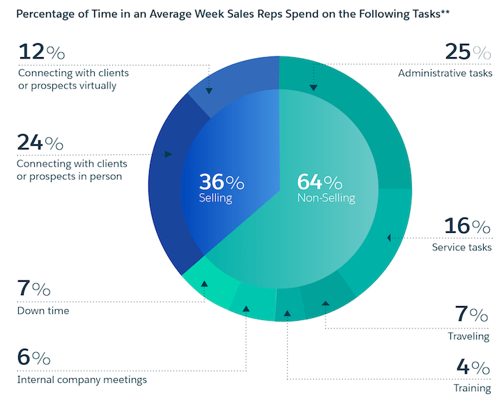
But restricting the number of routes a rep can map out not only takes up a big chunk of their time, it makes it easier for prospects to slip through the cracks. If they’re rushing to manually map out routes, they might miss potential prospects in the area.
How to Map Sales Territories Faster and More Efficiently with SPOTIO
Here are 5 ways using a sales territory management app can supercharge your sales efforts.
1. Map Territories With Demographic Data
To start selling smarter, you need data.
Using a sales tracking app, you can build sales territories using prospect data you’ve already got on file. When your sales reps are out in the field, they’ll be able to see every prospect and customer’s geographic location.
This can save them valuable time if they’re out selling and a new lead enters your company’s sales pipeline. Because SPOTIO helps build a rep’s selling route, it can automatically adjust their route if the new prospect is in the area, so they don’t fall through the cracks.
2. Pinpoint Existing Customers & Get Referrals
For reps out in the field, using existing customers as examples can be a powerful tool in their sales toolkit.
Picture this. Your rep is canvassing a street, and they can see on their app that the prospect’s neighbor is an existing customer of your company.
This will give your outside rep the ammunition to open their pitch with something like, “You know John Smith next door? He actually hired us last month and was very impressed with the work we did. In fact, seven of your neighbors in the area have trusted us to work on their home.”
![]()
See how that ice breaker completely changes the tone of the conversation?
But having powerful data like this can also help supercharge your rep’s referral process, too. Your customers can provide your reps with some of the highest converting and cheapest leads– referrals. They just have to ask.
In fact, 86% of buyers want to be able to ask in-person questions before making a purchase, and a further 90% of all buying decisions are based on recommendations. So if a rep is out selling in the field and getting referrals at the same time, they can kill two birds with one stone.
3. Assign Territories By Number of Homes
Making sure that sales reps have enough doors to knock is essential to their performance and the amount of commission they can make.
But it’s also essential to maintain a balance in your sales rep’s workloads. Using a sales territory mapping app can help assign a fair number of homes to a territory in a more accurate way.
For example, using SPOTIO you can create fair, balanced territories for your reps in less than 10 minutes. Let’s say you want to assign each rep 300 houses to target for the week. Using SPOTIO, all you have to do is start drawing out an area, and the software will tell you the estimated number of homes in that territory.
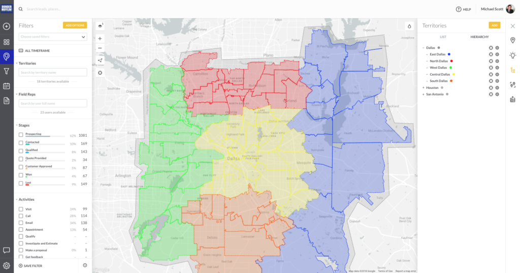
Once you reach the amount of houses you want each rep to target, all that’s left is to assign the territory so they can start selling.
4. Use City & Zipcode to Eliminate Grey Areas
Distributing territories by city or zip code is one of the easiest methods because it’s black and white.
There’s no grey area, and it minimizes the risk of sales reps crossing into each other’s territories. But there’s a catch. Assigning territories by city or zip code can lead to unbalanced territories, and one rep having higher amounts of prospects than another.
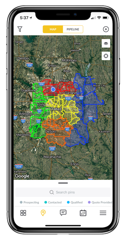
Because cities or zip codes vary in the number of houses, you may need to give two cities to a single rep, while one city might need three reps. Using SPOTIO to assign these territories can eliminate all this guesswork. SPOTIO can help to ensure you distribute the number of houses for each rep to work evenly by the city or zip code.
5. Use Google Places Data to Find, Filter & Target Businesses
SPOTIO’s native integration with Google Places makes it easier for reps to find the best prospects in their territories.
Let’s say your target prospects are restaurant owners. Using Google Places, sales reps can pull up every restaurant in the area, and then SPOTIO will automatically plan out the best route for them.
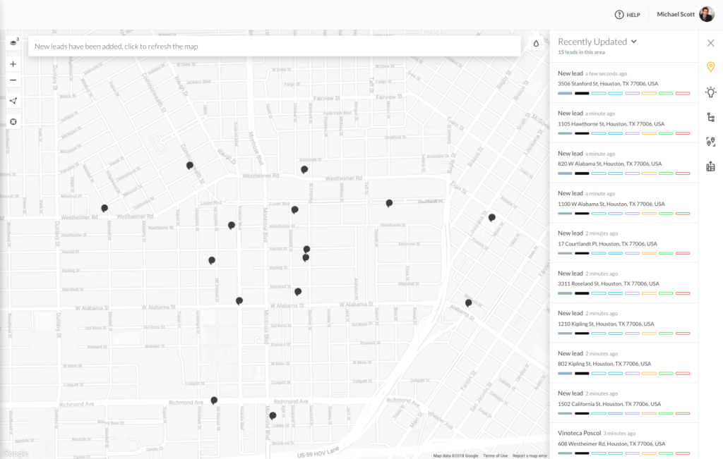
And because Google Maps is constantly staying up to date with businesses’ information, your reps won’t be wasting time in the field chasing down leads with outdated addresses.

Integrating Google Places into your rep’s sales plans can make sure the prospect information they’re using is up to date.
Final Thoughts
Google Maps is a great tool to help find a restaurant if you’re out walking the streets. But if you’re trying to use it for sales territory mapping, it’s another story.
For sales reps to be successful in the field, they need more than just a map with boundary lines on it. They need existing customer information, demographic data, and smarter sales routes.
Planning sales territories in Google Maps may be free, but it’s also very limiting. When you add up the cost of lost prospects and the extra admin time spent manually planning routes, ask yourself… what’s free mapping software actually costing your business in the long run?
______
SPOTIO is the #1 field sales acceleration platform designed specifically for outside sales managers and reps to squeeze every drop out of their field sales efforts.

